On this page
Heights & Orthometric Elevation
Check the height reference before comparing a measurement with a plan or benchmark. Pole height, antenna offset, and geoid choice all affect the result.
The height chain
The antenna phase center (APC) is located 9.4cm (0.094m) from the bottom of the RoboDot.
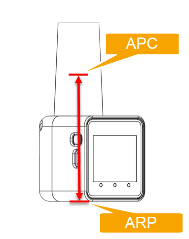
This distance is available on the RoboDot Touch Screen settings page.
When you mark a point, RoboDot computes the ground elevation for you:
ground = measured height at the APC − antenna offset (0.094 m) − pole height
That ground elevation is ellipsoidal. Its reference frame comes from the base position or correction service; do not assume it is WGS84. See UTM Coordinates.
Ellipsoidal vs orthometric
Orthometric heights describe elevation relative to a geoid model, an approximation of mean sea level. The difference from ellipsoidal height varies by location. Use the model and vertical reference required by your project.
RoboDot converts on the device using a geoid model file — no internet required.
Turning on orthometric heights
- Open the Web UI Settings page.
- Under Ortho Height, pick a geoid model from the dropdown. The list shows the models installed on your device, such as EGM96.
- The change takes effect immediately — no restart.
Where orthometric heights appear
- Status page — the position card shows Ortho H alongside the ellipsoidal height.
- Point exports — CSV exports include orthometric ground heights when a geoid model is active and covers the point. GeoJSON export is unavailable in current firmware.
Orthometric values carry the model name, such as 412.301 (EGM96). Check the label and model coverage before using a value as a project elevation.
If the model you need is not listed, contact Robota about supported options. The internal storage card is not user-accessible.